DACF Home → Bureaus & Programs → Maine Geological Survey → Maps, Publications and Online Data → Using Geologic Maps → Bedrock Ground-Water Resources Maps → Sidebar
Sidebar Information Shown on Bedrock Ground Water Resources Maps
Bedrock Well Data
The Maine Geological Survey collects a variety of information about bedrock wells drilled in the state. The data is portrayed on a series of maps showing well yield, depth, and thickness of overburden.
Bedrock Well Yield
Bedrock wells in Maine most often yield relatively small quantities of water. The median yield for a bedrock well is between 3 and 6 gallons-per-minute (gpm). Approximately 35% of bedrock wells drilled in Maine yield 10 or more gallons per minute.
Clusters of wells with yields of 10 gpm or more may define zones favorable for bedrock ground water exploration. The final well yields of domestic wells are not solely dependent on the geology of the bedrock, however. Other factors such as cost and borehole storage may determine the final acceptable yield for a well. Also, at the scale of these maps the brittle fractures that are the primary control on well yield may be smaller than the well symbol. For this reason, we have not attempted to outline zones of high yield wells on the map, and want to emphasize that the yield data presented on the map should be used cautiously when evaluating potential well yields in an area.
Bedrock Well Depth
The total depth of a well refers to its finished, or completed depth. For most domestic wells, it is the depth to which the driller goes in order to obtain the desired yield and/or provide adequate storage in the well for peak demand at the available yield. The final depth of a well depends on where water-bearing fractures are encountered in the well, the well yield, and the estimated peak demand. Sufficient storage must be provided to supply peak demands in low-and intermediate-yielding wells, and the pump must be placed deep enough to provide protection against drawdown during heavy use. Again, however, other factors such as cost may determine the final depth of a well.
Total depth includes the thickness of overburden penetrated. Plotting the total depth of many water wells in an area shows the typical depth at which sufficient water usually can be obtained. The information may be helpful in assessing the general range of well depth necessary in a given region. It is also suggestive of geologic controls, both bedrock and surficial, that, if understood, can help in the selection of the most favorable well sites in the crystalline bedrock.
Overburden Thickness
Loose soil deposits (overburden) are a source of water not only for dug wells or well points, but also for bedrock wells. Permeable soil cover permits a greater rate of infiltration of precipitation and transmits this water downward to the bedrock. When a well in the bedrock is pumped, ground water from the overlying saturated overburden moves downward into the bedrock in response to the pumping and maintains the yield of the well. Thick, coarse-grained deposits are the most favorable for providing recharge to the bedrock ground water system.
Overburden thickness and type are related to ground water contamination as well as to yields. Because most purification processes take place in the unsaturated zone above a water table and in the loose sediment overlying the bedrock, overburden thickness is indicative of the susceptibility of the local bedrock ground water system to pollution from surface sources of contamination. Bedrock overlain by thin, coarse-grained deposits is most susceptible to contamination.
Other Maine Geological Survey Publications
Caswell, W. B., 1987, Ground water handbook for the State of Maine (second edition): Maine Geological Survey, 135 p.
Significant aquifer maps (1:24,000) portray water-bearing sand and gravel aquifers and information about water wells.
Surficial geology maps (1:24,000) show the distribution of sediment types.
Surficial materials maps (1:24,000) provide information about overburden thickness and sediment type.
Anatomy of a Drilled Bedrock Well
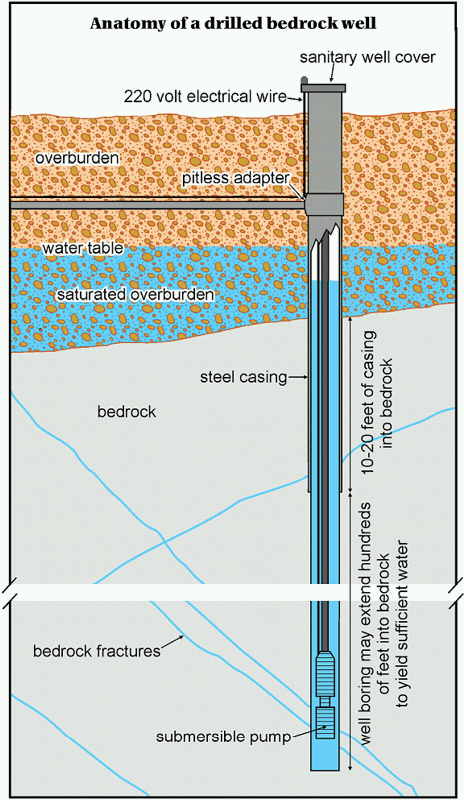
Using a drill rig, well drillers begin by drilling a hole about 9" in diameter through the overburden sediment overlying bedrock. When bedrock is encountered, drilling continues until competent bedrock is reached, generally between 10 and 20 feet. Steel casing is then installed in this hole and sealed to the bedrock. This casing seals the well from potential contaminants from surface infiltration. Drilling continues through the bottom of the casing until water-bearing fractures are encountered. Ground water fills the well to a level based on local geologic conditions. A submersible pump is then lowered into the well to bring water to the surface. The well casing protrudes out of the ground surface and is covered with a sanitary cap to prevent contamination. The water in the well above the pump is in storage and is available to be pumped out when needed. A bedrock well with low yield can still provide enough water for household use if the well boring itself holds enough water in storage to meet periods of peak demand.
Last updated on April 26, 2012