Home → Bureaus & Programs → Bureau of Parks and Lands → Find Parks & Lands → Park Details
 Maine Trail Finder
Description
Please check for access and COVID-19 updates by using this link to the Bureau's Safety page.
Enjoy backcountry hiking, fishing, and camping by clear ponds and rugged hills.
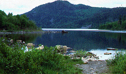
The 21,871-acre Deboullie Public Lands offer remote campsites on crystal-clear trout ponds surrounded by low rugged mountains. These lands, encompassing 17 ponds ranging in size from 8 to 341 acres, lie in northernmost Maine, east of the Allagash Wilderness Waterway and 30 miles from the Canadian border.
The area has a reputation for outstanding fisheries, with native brook trout in many ponds and landlocked salmon and lake trout in Togue Pond. Several ponds have populations of blueback trout (landlocked arctic charr), an unusual variety that is the world's northernmost freshwater fish.
A 12-mile trail network with several loop options leads to many remote ponds and to Deboullie Mountain (1,981 feet) where a former fire tower offers expansive views of the surrounding region. Hikers can enjoy mountaintop blueberries in August and still find "ice caves" in denser woods - narrow, shaded crevices where snow and ice can remain year-round (supporting unusual plants such as the arctic sandwort). Several small waterfalls offer attractive places to cool off during warm-weather hikes.
During winter, snowmobilers frequently pass through Deboullie Public Lands, enjoying the scenic beauty of its remote ponds on their way between Eagle Lake and the Allagash. The only maintained trail is the primary public access road, which forms an important connector in the State's Interconnected Trail System (ITS).
The ponds, streams, marshes and forests at Deboullie support an array of wildlife, and visitors may spot black bears, loons, moose and birds of prey. The wetland habitats support the rare northern bog lemming while upland forests offer shelter to the elusive Canada lynx. The Deboullie Public Lands incorporate a State Ecological Reserve, a 7,253-acre area that encompasses the shorelines and waters of 11 ponds. Its sensitive ecosystems (including old-growth spruce and mature hardwoods) will remain in their natural condition and be monitored over time.
If you are interested in learning about geology around the state, check out the Maine Geological Survey Searchable Database.
Please Note:
The State of Maine is a member of North Maine Woods, an organization that manages recreation on nearly three million acres in northern Maine. Day use and camping fees collected at various checkpoints defray the costs of managing public access and maintaining recreation facilities. This unit is within the North Maine Woods system, so visitors must pass through a checkpoint and pay the required day use and camping fees. North Maine Woods can be contacted at (207) 435-6213.
Click here to download our current printer friendly copy of the Deboullie brochure.
Services & Facilities
- 29 primitive single-party campsites with privies (23 of which are drive-to) on or near Togue, Denny, Perch, Upper, Pushineer, Deboullie and Gardner Ponds. One group campsite is available on Perch Pond.
- 12 miles of hiking trails (including pond destinations and Deboullie Mountain)
- Four trailerable boat launches (on Togue, Perch, Pushineer and Deboullie Ponds)
- One hand-carry boat launch (on Sixth Pelletier Brook Lake)
History
The name Deboullie is an adaptation of the French word, débouler, which means to tumble down - referring to the talus fields (former rock slides) at the base of several mountains. The hills around Deboullie derive from an extremely hard metamorphic rock formed roughly 370 million years. The sheer cliffs of Deboullie were carved by glaciers that eroded softer shale and left only the harder rock. Without vegetation, steep sections of rock eroded to form the talus (boulder) fields that still border many of the ponds.
While native tribes have inhabited this forested region for roughly 10,000 years, the Deboullie lands were more likely hunting and fishing grounds (being too far from a major river to have a significant settlement). After European settlers arrived in the mid-1800s, the area was logged for roughly a century (with heavy cutting most recently in the late 1950s and 1960s). Between 1910 and 1920, two mills were constructed along with the dam on Pushineer Pond.
The rich fishing opportunities and scenic attractions of this remote region have lured outdoor enthusiasts for more than a century. A cabin on Island Pond, now part of a private sporting camp, was originally built before 1900 as a private camp of the Whitman family (of Whitman’s Chocolates). One of the early camp owners reportedly brought - not just his family - but a tutor for his children, a barber, and a piano player for evening dances.
The State acquired the initial Deboullie lands in 1975 as part of a larger land trade with Great Northern Nekoosa Corporation involving other properties around Maine. Similar trades in 1984 and 1985 enabled the State to assemble the current tract, which encompasses all of Township 15 Range 9 (Deboullie Township).
Activities
- Boating (motorized)
- Camping
- Canoeing
- Cross-country skiing
- Fishing
- Hiking (trails)
- Hunting
- Picnicking
- Snowmobiling
- Snowshoeing
- Swimming
- Watchable wildlife
Rules
- Kindle fires only in authorized campsites with fire rings and cut no live vegetation. Permits are not required for fires at authorized sites.
- Carry out all trash.
- All those fishing must have a valid license and review the State's open water fishing regulations. Fishermen are asked to use lead-free sinkers and jigs to prevent metal poisoning of loons, eagles and other wildlife.
- Use no chainsaws, generators or other power equipment around campsites.
- Do not discharge weapons within 300 feet of any picnic area, camping area, parking area, posted hiking trail or other developed area. Loaded firearms are not permitted at campsites or on hiking trails.
- No reservations are required and sites are first-come, first serve. Camping stays on Maine public lands are limited to 14 days in any 45-day period. Bureau of Parks and Lands staff may take custody of any personal property left unattended for more than 3 days (unless advance written permission is given).
Consider lending a hand. Contact us if you would like to help with stewardship or maintenance work.
Trails
Deboullie Mountain Trail (4-mile roundtrip, allow 4 hours) begins by a parking area at the east end of Deboullie Pond. The trail follows the pond shore west for 1.3 miles and crosses a large rockslide before entering a clearing with a picnic site - where a side trail heads steeply up for six-tenths of a mile to the summit (with views in all directions from the 48-foot fire tower). Look for ice caves along the way (crevices where ice can remain year-round).
Deboullie Loop Trail (6-mile roundtrip - not counting spurs, allow 4 hours) begins at the east end of Deboullie Pond, and follows the pond shore west 1.3 miles, passing the summit trail, and continuing west 0.8 miles to the end of the pond. The trail turns south (with a short spur leading to Gardner Pond) and then forks. The right spur goes 1.4 miles through woods to Denny Pond. Continue left, going 2.7 miles though woods to the shore of Pushineer Pond. The hiking trail continues at the road to Red River Camps with a one-mile walk along the access road leading back to the original trailhead.
Black Mt. Loop Trail (5.5 miles round trip, allow 4 hours) begins at the east end of Deboullie Pond. Follow the Little Black Ponds Trail to Black Pond, then the right-hand trail to Black Mountain. The scenic vista on Black Mountain provides spectacular views of Black Pond and the surrounding forest. The trail continues along the top of Black Mountain, across the saddle Deboullie Mountain and Black Mountain then up the north side of Deboullie Mountain to the tower. Follow the Deboullie Mountain Trail back to the trailhead parking. Natural Heritage Hike for this trail.
Visit the Deboullie Public Reserved Land map at Maine Trail Finder.
Tours and Programs
Visit Take-It-Outside for Maine Bureau of Parks & Lands events.
Services and Facilities
- Trailered boat launch
- See Visitor Accessibility
Special Considerations
Deboullie Public Lands lie within the North Maine Woods recreational system: visitors must pass through a checkpoint and pay the required day use or camping fees. The State of Maine is a member of North Maine Woods, an organization that manages recreation on nearly three million acres in northern Maine. Fees collected at checkpoints defray the costs of managing gate systems and maintaining recreational facilities.
The Maine Department of Inland Fisheries and Wildlife (MDIFW) Warden Service does search-and-rescue operations and enforces state fish and game laws, boating laws (on inland waters), and ATV and snowmobile laws. To learn more about applicable laws and to purchase appropriate licenses, visit www.maine.gov/ifw.
Buy only local firewood and thoroughly clean boats and motors to avoid importing invasive plant and animal species. Buy It Where You Burn It
Observe wildlife from far enough away that they do not change their behavior: do not follow or feed animals. Avoid areas with nesting birds, dens or young animals (even those that appear abandoned).
Take care traveling along area logging roads, pulling over and stopping for trucks regardless of which direction they're headed. Avoid roads that are too narrow for two vehicles, do not block side roads and never stop where visibility is poor. Roads can be dusty in dry weather and washed out in wet weather. Gravel roads are hard on tires (and suspension systems): travel slowly and carry a spare tire.
Abundant moose, bear and other large animals in the North Woods can create hazards when in close contact with people (or their vehicles). Drive slowly on area roads (particularly at times of low light) and observe wildlife from a safe distance. Keep food items securely stowed or hung when camping and make sure that tents and their contents are free of food and food odors.
Red River Camps leases property from the Maine Bureau of Parks and Lands and operates a traditional sporting camp on Island Pond.
Don't count on your cell phone in an emergency as coverage is spotty to non-existent.
When to Visit
Open All Year, Fee Charged.
Boaters and campers enjoy visits during warm weather months, followed by hunters in October and November. Surface fishing for salmon and trout is usually best in the weeks following ice out (typically early to mid-May) or when waters cool in September. Be prepared for black flies and mosquitoes, particularly in May and June. Fall foliage season is a spectacular time to observe the display of color.