Home → Bureaus & Programs → Bureau of Parks and Lands → Find Parks & Lands → Park Details
 Land and Water Conservation Fund
 Maine Trail Finder
Description
Fort Popham conditions will be monitored and access is subject to change. Please check for access and COVID-19 updates by using this link to the Bureau's Safety page.and text DACF POPHAM to 468311 to subscribe to the park's Condition Alerts.
Location Lat 43.755110 / Lon -69.783374 15 miles from Bath on Maine Route 209 at 219 Popham Rd.; continue past Popham Beach State Park for two miles miles. Route 209/Popham Rd. will deadend at the parking for the Fort.
Hours / Season
Open 9:00 a.m. to sunset daily from April 15th to October 30th. Fee charged. Visitors may continue to enjoy the park during the off season by parking outside the gate and walking in during these same hours. Please be aware that facilities are closed during the off season.
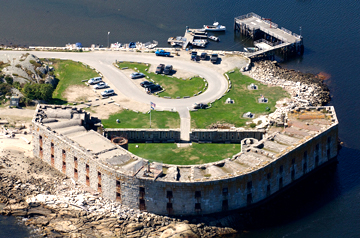
Fort Popham is a semi-circular granite fort that was never completed, though construction began in 1862 for use during the Civil War. Modifications were made and the fort was used again in the Spanish American War and in World War 1. Historical records conclude that fortifications, probably wooden, existed here and protected the Kennebec settlements during the Revolutionary War and the War of 1812. It was nearby that the English made their first attempt to colonize New England in 1607.
If you are interested in learning about geology around the state, check out the Maine Geological Survey Searchable Database.
The Land and Water Conservation Fund contributed to this State Park.Learn more about LWCF.
Activities
- Beaches
- Fishing
Rules
Consider lending a hand. Contact us if you would like to help with stewardship or maintenance work.
Services and Facilities
- Picnic area
- See Visitor Accessibility