DACF Home → Bureaus & Programs → Maine Natural Areas Program → Communities, Plants, and Animals → Natural Community Fact Sheets → Tall Grass Meadow
Printer Friendly Fact Sheet - 850 KB pdf (Get a free copy of Adobe Acrobat Reader)
Tall Grass Meadow
Scientific Name: Bluejoint Meadow; State Rank: S4
- Community Description
- Soil and Site Characteristics
- Diagnostics
- Similar Types
- Conservation, Wildlife and Management Considerations
- Distribution
- Characteristic Plants
- Associated Rare Plants
- Associated Rare Animals
- Examples on Conservation Lands You Can Visit
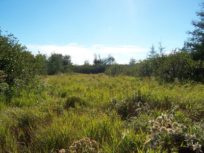
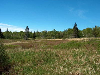
Community Description: These dense swards of tall grassy vegetation are dominated by bluejoint, with smaller amounts of shrubs (alder, meadowsweet, willow) mixed in. Depending on the disturbance history, the shrubs may be low and not easily visible among the grasses, or taller, in which case the vegetation appears as mixed shrub-graminoid. Other graminoids, such as tussock sedge and other sedges are occasional. Flat-topped white aster and spotted joe-pye weed are common tall forbs. Freshwater cordgrass is often present in small amounts. Bryophytes are very minor (0-10% cover), and lichens are absent. Two principal variants occur; those in alluvial soils of larger rivers and those of more peaty soils along small streams. Back to top.
Soil and Site Characteristics: Sites occupy mineral soils in temporarily flooded rivershores or streamsides that are flat to slightly sloped. At some sites this type extends onto poorly drained uplands as grassy barrens. Soils are sandy to silty along rivers, with higher clay or organic content in other settings. The acidic to neutral soils (pH 5.0-7.0) are saturated or moist not far from the surface. Most sites are disturbance maintained, either by ice scour flooding (larger rivers), by beaver flooding, or by fire (some Downeast grasslands). Back to top.
Diagnostics: Bluejoint grass exceeds 50% cover and shrubs are less than 25% cover. Sites are flooded for only part of the season. Whether the two variants should be separated as distinct types needs additional study. Back to top.
Similar Types: Sedge Meadows share many species, but have less bluejoint grass (usually <30% cover) and more tussock sedge (>30%). Grassy Shrub Marshes also can be floristically similar, but are not strongly dominated by bluejoint grass (usually <20%, rarely up to 50%). Other open non-peat wetland types are shrub dominated, not herb dominated. Back to top.
Conservation, Wildlife and Management Considerations: In the absence of disturbance (flooding or fire, the latter often human-initiated), this community develops into dense shrublands dominated by alder. Maintaining both the natural disturbance regime and the hydrologic integrity of these systems is key to their conservation. Several high quality examples occur on public lands and private conservation lands. Northern leopard frogs inhabit large grassy meadows associated with rivers in mid-summer where they forage. Northern harriers, Lincoln's sparrows, and rare short-eared owls may also nest and forage in these meadows.
Northern Maine sites may provide grassy nesting sites for very rare breeding waterfowl such as northern pintail, northern shoveler, and gadwall. Back to top.
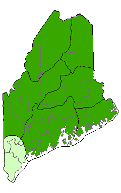
Distribution: Larger rivers of far northern Maine, coastal grasslands of Downeast Maine (New England - Adirondack and Laurentian Mixed Forest Provinces), and meandering streams statewide. Distribution outside of Maine is not clear. Landscape Pattern: Small patch; some Downeast grasslands approaching Large Patch. Back to top.

Characteristic Plants: These plants are frequently found in this community type. Those with an asterisk are often diagnostic of this community.
- Sapling/shrub
- Meadowsweet
- Speckled alder
- Herb
- Bluejoint*
- Flat-topped white aster
- Tall meadow-rue
- Tussock sedge*
- Bryoid
- Sphagnum mosses
- Short-eared owl
- Yellow rail
Examples on Conservation Lands You Can Visit
| Example | County |
|---|---|
| Allagash Public Lands | Aroostook Co. |
| Cutler Public Lands | Washington Co. |
| Narraguagus Wildlife Management Area | Washington Co. |
| Petit Manan Point, Petit Manan National Wildlife | Washington Co. |
| St. John River Preserve | Aroostook Co. |