This page was updated January, 2025
Overview
The State of Maine launched the Maine Offshore Wind Initiative in 2019 to explore the development of offshore wind (OSW) energy in the Gulf of Maine that balances the needs of the state’s maritime industries and the health of the environment.
More information about Maine's OSW initiative and the Offshore Wind Roadmap can be found here.
In Maine, plans are taking shape for a research lease that strives to answer critical questions about the impacts of OSW on fishing and the environment prior to commercial development.
The Bureau of Ocean Energy Management (BOEM) is responsible for all renewable energy development in federal waters, including commercial and research offshore wind leases. On August 19, 2024, the State of Maine and Bureau of Ocean Energy Management (BOEM) reached an agreement on a floating offshore wind research lease, a significant milestone in the development of offshore wind energy for Maine.
Gulf of Maine Floating Offshore Wind Research Array
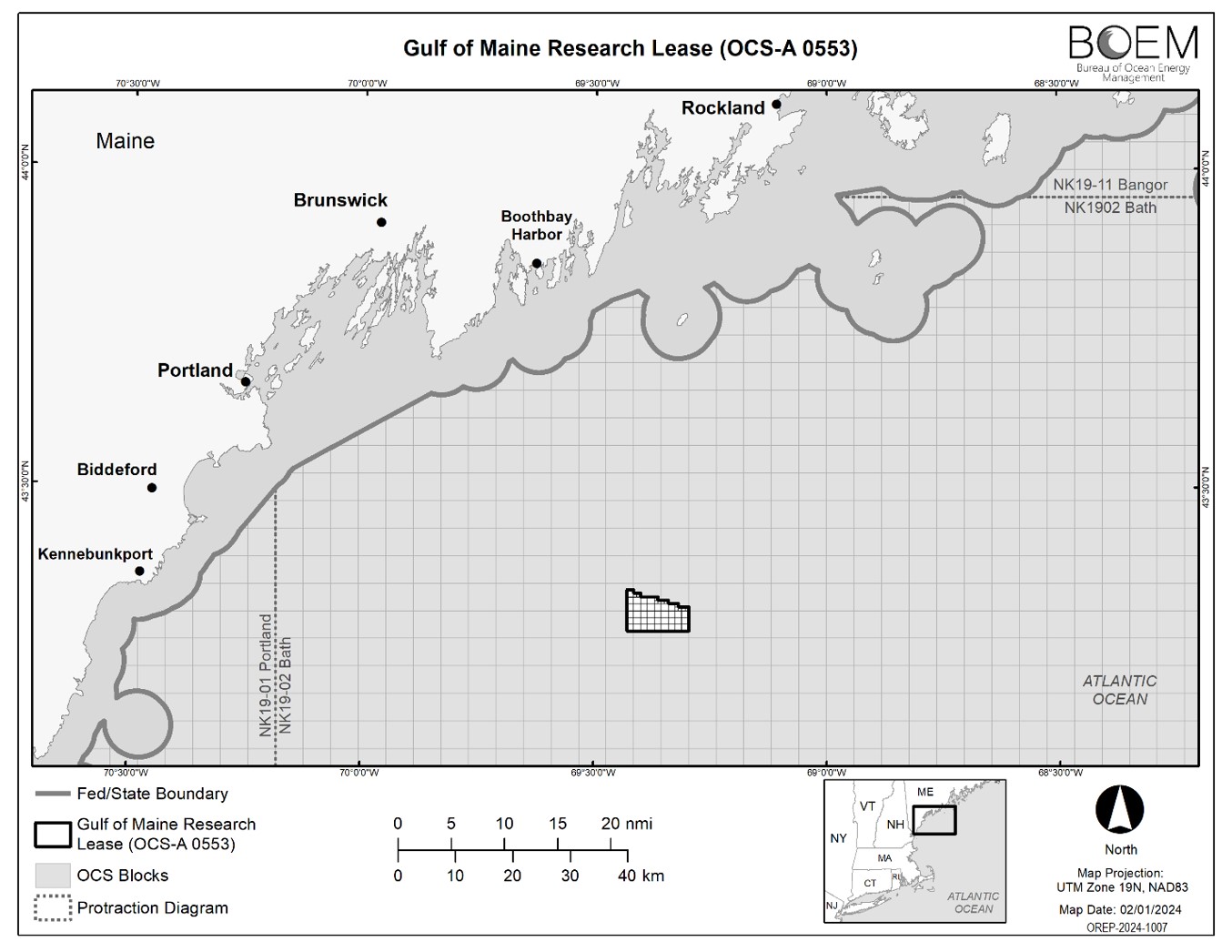
The goal of Maine's offshore wind research lease is to better understand the impacts of OSW on the ecosystem and fisheries in the area. To learn more about how the specific site was chosen for this research lease, goals of the project, or the State’s efforts around offshore wind planning, additional information can be found on the state’s project website.
The State of Maine through the Governor's Energy Office is the lease applicant for the project, and its development partner, Diamond Offshore Wind, will construct and operate the array.
Going Beyond BOEM Requirements for Surveys and Monitoring
For every OSW lease, BOEM requires studies that evaluate the impact of proposed activities on physical, biological, and socioeconomic resources and assess the seafloor and sub-seafloor conditions that could be affected by the construction, installation, and operation of towers, buoys, cables, wind turbines, and supporting structures.
As the lease applicant, the State of Maine is responsible for submitting to BOEM a plan to conduct the studies and the information gained through the studies. Diamond Offshore Wind will develop the required plans and studies for BOEM on behalf of the state.
Consistent with recommendations in the Maine Offshore Wind Roadmap, the State of Maine will also go beyond these requirements by conducting additional surveys that produce a more comprehensive evaluation of the research lease area.
The Department of Marine Resources (DMR) will take the lead on many of the additional surveys on behalf of the state. Surveys planned by DMR will expand the spatial footprint, duration, frequency, and intensity of studies required by BOEM.
DMR will submit plans and studies to BOEM that are guided by recommendations from the Fisheries Working Group for the Maine Offshore Wind Roadmap. The Roadmap describes how Maine can develop offshore wind energy with minimal impacts to the marine ecosystem, coastal communities, and ocean users.
Pre-construction surveys will gather baseline data on local oceanographic conditions, resource abundance and distribution, and relationships between resources and ocean conditions. This information can then be compared to the data collected throughout the construction and operation phases of the research array to understand if/how conditions, abundances, distributions, and/or relationships change due to these construction and operation.
Surveys will include: Oceanographic monitoring; plankton and larval lobster survey; lobster trap survey; seafloor mapping and characterization; bottom trawl survey; active acoustic survey; highly migratory species monitoring; passive acoustic monitoring; visual wildlife survey; ecosystem modeling; and socio-economic and local historical knowledge survey.
Below is an illustration and table of each survey DMR will be conducting, indicating the type of survey, goal for each survey, and organizations partnering with DMR on the survey work.
| Survey | Survey Type | Goal | Partner Organizations |
| Oceanographic Monitoring | Shore-based radar stations | Understand changes in surface water velocity and wind patterns after turbine installation | University of Maine, Woods Hole Oceanographic Institution |
| Glider surveys | Understand water conditions and stratification after turbine installation | University of Maine | |
| Plankton and larval lobster survey | Vertical plankton tows | Understand baseline water conditions, stratification, and plankton community composition and distribution and determine if they change during and after turbine installation | Bigelow Laboratory for Ocean Sciences, University of Maine, University of Southern Maine |
| Horizontal neuston tows | To understand baseline larval lobster abundance and distribution and determine if it changes after turbine installation | Bigelow Laboratory for Ocean Sciences, University of Maine, University of Southern Maine | |
| Lobster trap survey | To understand baseline lobster size and sex distribution and movement patterns and determine if it changes during and after turbine installation | ||
| Seafloor mapping and characterization | Mapping | To collect baseline bathymetry data | |
| Benthic grab sampling | To understand baseline benthic community and sediment characteristics and determine if they change during or after turbine installation | ||
| Bottom trawl survey | To evaluate fish and invertebrate community composition in proximity to the seafloor | ||
| Active acoustic survey | Acoustic survey | To understand baseline fish and invertebrate community composition and movement patterns and determine if they change during or after installation | Gulf of Maine Research Institute |
| eDNA samples | To ground truth acoustic signals | Gulf of Maine Research Institute | |
| Highly migratory species monitoring | Tagging | To understand baseline species abundance and distribution and trophic interactions and determine if they change during or after turbine construction | University of Maine |
| Deployment of receivers | To reconstruct broad- and fine-scale distributions and habitat use of the area by highly migratory and benthic fishes before, during, and after turbine installation to determine if there are any changes due to turbine construction | University of Maine | |
| Passive acoustic monitoring | To identify species and understand baseline abundance, distribution, and movement patterns and ambient noise and determine if they change during or after turbine installation | ||
| Visual wildlife survey | To ground truth passive acoustic data and understand baseline species presence and abundance and determine if they change during or after turbine installation | ||
| Ecosystem modeling | To understand how resources and conditions are connected in the ocean ecosystem in the area of the Maine Research Array and to predict how direct changes from turbine installation may have indirect effects | University of Maine | |
| Socio-economic and local historical knowledge | To understand current and past uses of the proposed area for the Maine Research Array and to create a framework for gathering information from ocean users | University of Maine, Maine Coast Fishermen’s Association |
Questions about the Maine Research Array can be sent to offshorewind@maine.gov. To sign up for email updates from the Initiative: https://www.maineoffshorewind.org/email-signup/